Governor Commits To Planning, Priorities For Copper Valley's Wild Country Roads – With Local Input
Richardson Highway in 1923, a hundred years ago near Black Rapids (Alaska Digital Archives) First rural planning organization in Alaska wi...

Richardson Highway in 1923, a hundred years ago near Black Rapids (Alaska Digital Archives)
 |
| Richardson Highway in 1923, a hundred years ago near Black Rapids (Alaska Digital Archives) |
First rural planning organization in Alaska will help prioritize area transportation funding, state says
August 13th, 2022PRESS RELEASE FROM DOT:
(FAIRBANKS, Alaska)—The first Rural Planning Organization (RPO) was established in Gulkana, Alaska over the weekend when Governor Mike Dunleavy signed a cooperative agreement between the Copper Valley Development Association (CVDA), and the Alaska Department of Transportation & Public Facilities (DOT&PF). The RPO pilot program will establish a structure for local and regional input and information exchange on transportation planning and prioritization for the Copper Valley Census Area.
“Supporting the communities of Copper Valley in their efforts to build and expand their economy through infrastructure development is rewarding,” said Governor Dunleavy. “I look forward to hearing more about what this new partnership can accomplish.”
There are several different types of transportation planning organizations, such as a Metropolitan Planning Organization (MPO) and a Rural Transportation Planning Organization (RTPO). Each of these planning organizations, including the RPO, is formed to give communities a voice in transportation planning and spending. The benefit of starting an RPO is to allow flexibility while rural regions develop capacity to participate in a wide range of transportation planning efforts.
“It is exciting to partner with communities for the future of transportation,” said DOT&PF Commissioner Ryan Anderson. “Direct community involvement in transportation planning builds a more resilient transportation network.”
The Copper River Census Area includes Copper Center, Tazlina, and Gulkana. The Copper River Region is an Unorganized Borough with no municipalities or other form of governmental organization. The region includes the Gulkana Airport, a regional hub, the Glenn and Richardson Highways, which offer surface transportation links to Anchorage, Valdez and Fairbanks. Additionally, the Copper River Census Area has two Alaska Highway System routes, the McCarthy and Nabesna Roads, which connect to the Wrangell-St. Elias National Park, which is the largest national park in the United States.
NOTES: THE COPPER RIVER COUNTRY JOURNAL
Commentary On Statements By DOT About Copper River Roads & Communities
The Copper River Census Area covers 24,692 square miles. It has an estimated population of around 2,630 to 2,800 people. The exact number isn't known.
In addition to Copper Center, Tazlina, and Gulkana Village (all mentioned above by DOT in its recent press release) other places in the census area include: Chisana, Cheesh'na Village, Chistochina, Chitina, Chitina Village, Copperville, Gakona Junction, Gakona Village, Glennallen, Kennicott, Kenny Lake, Kluti-Kaah Village, McCarthy, Mendeltna, Mentasta Lake Village, Nabesna, Nelchina, Paxson, Silver Springs, Slana, Tazlina Village, Tolsona, Tonsina, and Willow Creek.
Because the Copper River Census area is not incorporated, each of the above communities (other than the Native villages) is totally self-defined by its residents, and not an "official" town.
 |
| Copper River Country (For The Journal by David Mudrick) |
The "Copper River Census Area" is a new concept. Our region was taken out of the Valdez-Cordova Census Area in the past year or so by the State of Alaska and identified in its own right, partly because of the need for better Covid counts. The Copper River area is different from Valdez and Cordova, both of which run incorporated oceanfront city governments, have elected officials for their entire regions and have compact footprints.
See attached stories (below) in the Copper River Country Journal about the recent formation of the Copper River Census Area, separate from the Valdez-Cordova Region.
SEE: "Alaska Corrects Definition of 'Copper River' In Data Hub Presentation"
Although the Copper Valley is part of the Unorganized Borough, it is not exactly accurate that there's "no other form of governmental organization" in the region.
There are 7 official Alaska Native villages in the immediate Copper River valley: Cheesh'na Village, Chitina Village, Gakona Village, Mentasta Village, Tazlina Village, Kluti-Kaah Village and Gulkana Village.
Each of these villages has a well-established and recognized form of government that is fully accepted by both the state of Alaska and the U.S. government. Each of the village tribes has elected officials, and multiple rights of governance. It's the areas outside the villages that have no form of governmental organization.
 |
| Glenn Highway |
The Richardson travels south-to-north across the region. The Glenn and Richardson blend together between Glennallen and Gakona, before parting ways.
For Copper Valley people, the first 40 miles of the Denali Highway, starting at Paxson, is also considered a part of the region. The Mat-Su Borough starts at Mile 40.5 on the Denali.
 |
| Richardson Highway |
The main route into the Copper Valley is the Glenn Highway, which passes through the Matanuska-Susitna Borough, where there are many high and dangerous mountain passes.
 |
| Boulders as large as a Subaru fall off the cliffs at Long Lake. (Photo, Country Journal) |
You can also enter the Copper Valley by car from
Valdez, to the south; from Tok on the northeast; from Delta to the north, and from Cantwell to the west.
Although the Glenn Highway route is acknowledged by many residents to be particularly problematic (almost everyone who has been here awhile has seen turned-over semi trucks, or knows of people who have fallen off Caribou Creek curve) the Richardson Highway poses equal dangers.
 |
| Thompson Pass this spring. (Photo, Gary Minish) |
 |
| Tok Cutoff Detour |
There are times when the only way to Fairbanks from the Copper Valley is by detouring over the Tok Cutoff.
The Richardson Highway, headed to Valdez, can be so dangerous that there are multiple permanent barricades installed on the road. The barricades are kept up most of the time. In winter they are lowered by DOT to physically keep drivers off the road in bad weather. There are avalanche cannons near Thompson Pass, to shoot down avalanches in a safer and more controlled manner than allowing them to come down naturally.
The problems north of Paxson on the Richardson often revolve around high winds, extreme cold, and dangerous winter isolation.
The Denali Highway is closed to road travel in winter, and the end of the highway near Paxson is blocked by DOT with massive bulldozed snowbanks as a deterrent to motorists.
To understand the problems of the Copper Valley's "highways" (all of them two-lane country roads) we have to go back and look at some of the roads' histories. Originally, these roads were all made by hand, and it shows, even today.
RICHARDSON
The Richardson Highway is, at heart, a trail. It was put in place by the military as the "Valdez-to-Eagle Trail" at the start of the 1900s. Then, when gold was found in Fairbanks, a second leg was put in, beginning at Gakona Junction. That newer section of trail, from Valdez to Fairbanks, is what we now call "the Richardson Highway."
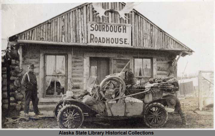 |
| Early Model T at Sourdough Roadhouse on the Richardson. (State Digital Archives) |
Even today, north of Gakona Junction, you can see the issues of the original Valdez Trail on the Richardson. Although DOT has been putting extensive work into the northern Richardson Highway, it is still a winding, narrow road in many places, with no shoulders. This is a vestige of its heritage. You can see how it was hacked through the black spruce forest, snaking across the landscape.
The original Richardson was a "winter trail." There were few actual bridges, so sledges headed to Fairbanks from Valdez traveled the Richardson in winter, when there was ice spanning rivers, lakes, ponds, swamps and creeks. There was a stagecoach station at the Gulkana River, and dozens of small roadhouses all up and down the trail to serve travelers who arrived at the lodges on sleds, wrapped in blankets, on their way from the ship in Valdez to their future homes in Fairbanks.
TOK CUTOFF
The Tok Cutoff was also a trail. It follows the part of the Valdez Trail that went to Eagle on the Yukon. Even into the 1950s, the current Tok Cutoff was a "winter trail" and suppliers freighted in goods on dog sleds to Chistochina Lodge and other places.
The Tok Cutoff (also, technically, an extension of "The Glenn Highway") is known for its susceptibility to deterioration from permafrost. Every few years, it sinks, in a wave-like, permafrost-driven collapse of the substructure of the road.
GLENN HIGHWAY
Before World War II, there was no road to Anchorage. The military worked to put it in, coming across Canada on the Alaska-Canada Highway, pushing their way down the Tok Cutoff. Where the Hub and Ahtna Building now are on the Richardson, road builders picked an arbitrary point and struck out from there toward Chickaloon, and then on to Anchorage, across the high country and mountains that stood in the way.
 |
| Harry Heintz helped scope out the original Glenn Highway. (Archive photo by Country Journal) |
The people who scoped out the Glenn were not professional road builders. Originally, as if it was still gold rush days, local people were asked to do the job. And, as if it was still the gold rush, the locals first used horses to mark the future road.
The road builders' choices (made while the men suffered from "beaver fever" diarrhea and their horses sank up to their necks in swamps) were not necessarily the best.
Difficult terrain, long distances, lack of professional road-building expertise, need for rapid decision making, spur-of-the-moment choices, and dangerous mountain passes led the Glenn to end up with serious drawbacks.
These include landslides, lack of guardrails, problematic shoulders, winding mountain passes (some of which have been rectified) and steep, unguarded cliffs. We are still dealing with the original issues of the Glenn Highway's impromptu origins to this day.
Nevertheless, the Glenn Highway is the primary road route to Anchorage from Canada.
DENALI HIGHWAY
Ahtna Natives used to get to the Denali Highway by walking there from Gulkana Village, on a trail that started at what is now "Bear Creek" near Gulkana.
The Denali Highway, starting at Paxson, eventually became a sled trail, and even now is a holdover from the old "winter trail" concept. The Denali Highway is technically closed in the winter, and unmaintained by DOT during that time.
 |
| Paxson DOT crew, digging out Denali Highway in spring of 2022 (Photo, DOT) |