Day of Heavy Rainfall Creates Muddy Conditions on the Clear Fire But It's Not Over Yet July 12th Clear Fire Report Weather: Scattered s...
https://www.countryjournal2020.com/2022/07/fires-across-state-grow-as-dry-winds.html
Day of Heavy Rainfall Creates Muddy Conditions on the Clear Fire But It's Not Over Yet
July 12th Clear Fire Report
Weather: Scattered showers and isolated thunderstorms are forecast to develop by the afternoon. Overall, temperatures are trending cooler this week with damper weather; there are chances of more showers with possible wetting rainfall in the coming days.
Fire Activity: There was significant rain, numerous thunderstorms and lightning for most of the day over the fire yesterday. This created unsafe working conditions throughout the fire area. The weather kept fire activity to a minimum throughout most of the fire area. While this weather may temporarily moderate fire behavior, it will take sustained periods of wetting rain to significantly decrease overall fire danger and make fuels less receptive to burning.
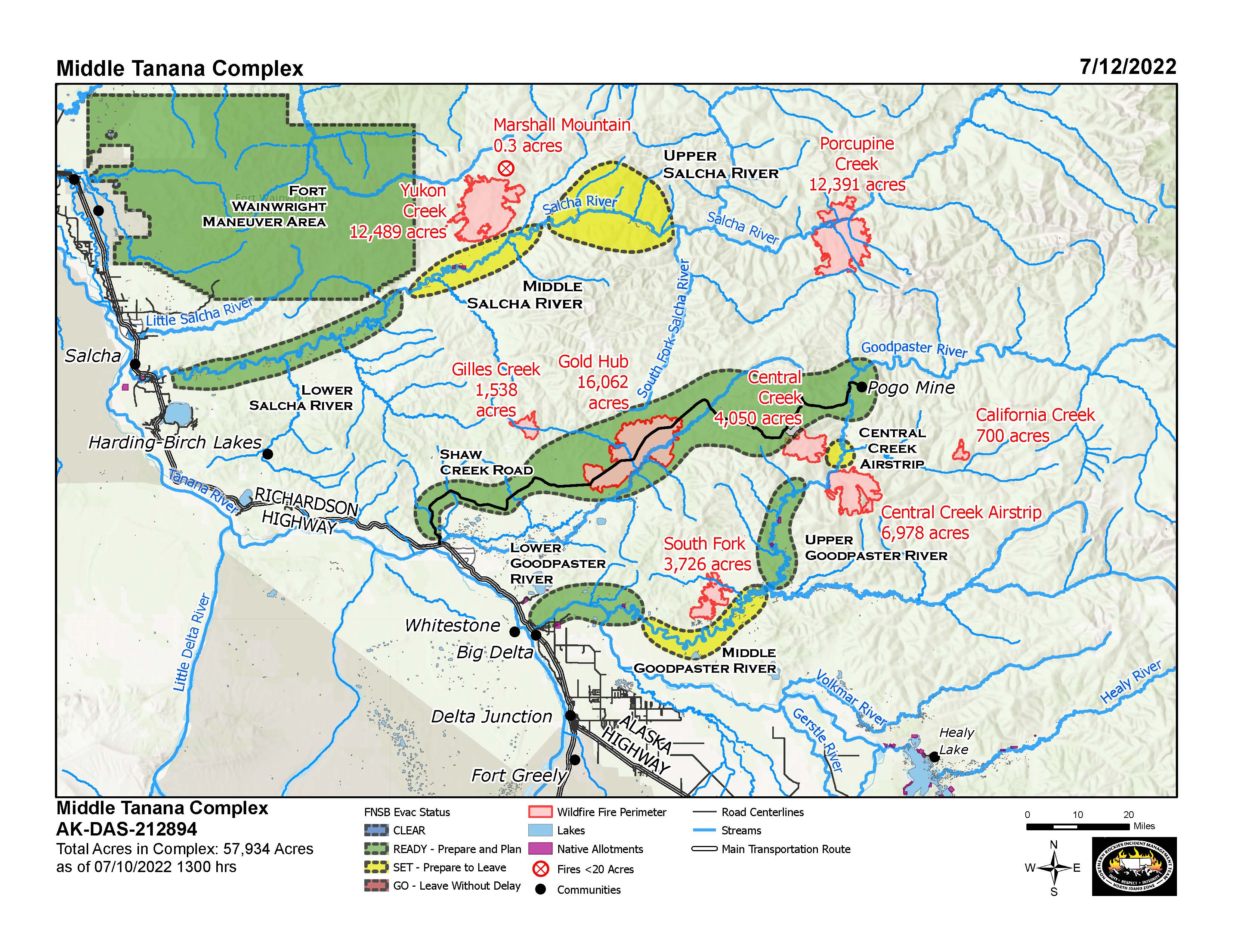
July 12th Middle Tanana Complex Report
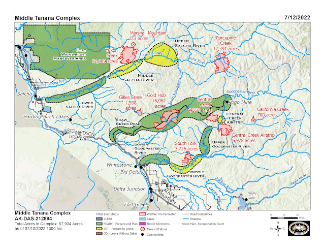 |
| The many fires between Delta and Fairbanks northeast of the Richardson Highway are collectively called the "Middle Tanana Complex". (Click To Enlarge) |
Fire activity remains low across the Middle Tanana Complex
Smokejumpers working on the north side of the Salcha River near the Yukon Creek Fire moved west to work on cabins near Flat Creek. They began installing hoses and pumps and removing flammable materials and hazardous fuels.
Up Shaw Creek Road towards the Pogo Mine, fire personnel are scouting for natural features to check the Gold Hub Fire should it become active again. A wildland fire module specializing in wilderness firefighting is working around mile 40 of Shaw Creek Road to protect the adjacent powerlines and scout for future opportunities to stop the Central Creek Fire. Minimizing impacts on the mine by maintaining power and access are priorities.
In the lower Goodpaster River corridor, the Crane Valley Hotshots continue to implement structure protection around cabins and buildings on the north side from river mile 26 to the confluence with the South Fork Goodpaster River. Weather permitting, crews plan to fly in today to check the sprinkler systems and pumps and monitor the fire activity around the Central Creek Airstrip.
The Porcupine, Gilles, Marshall Mountain, and California Creek fires are being monitored.
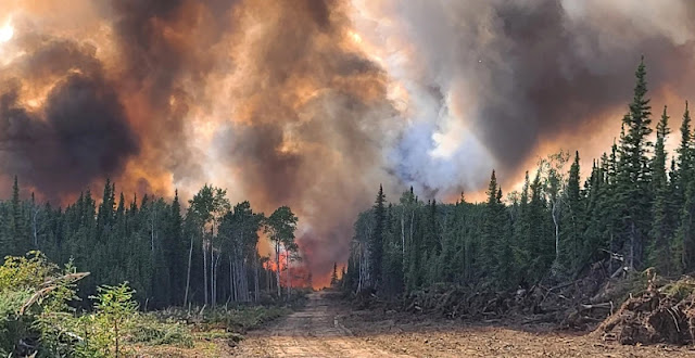
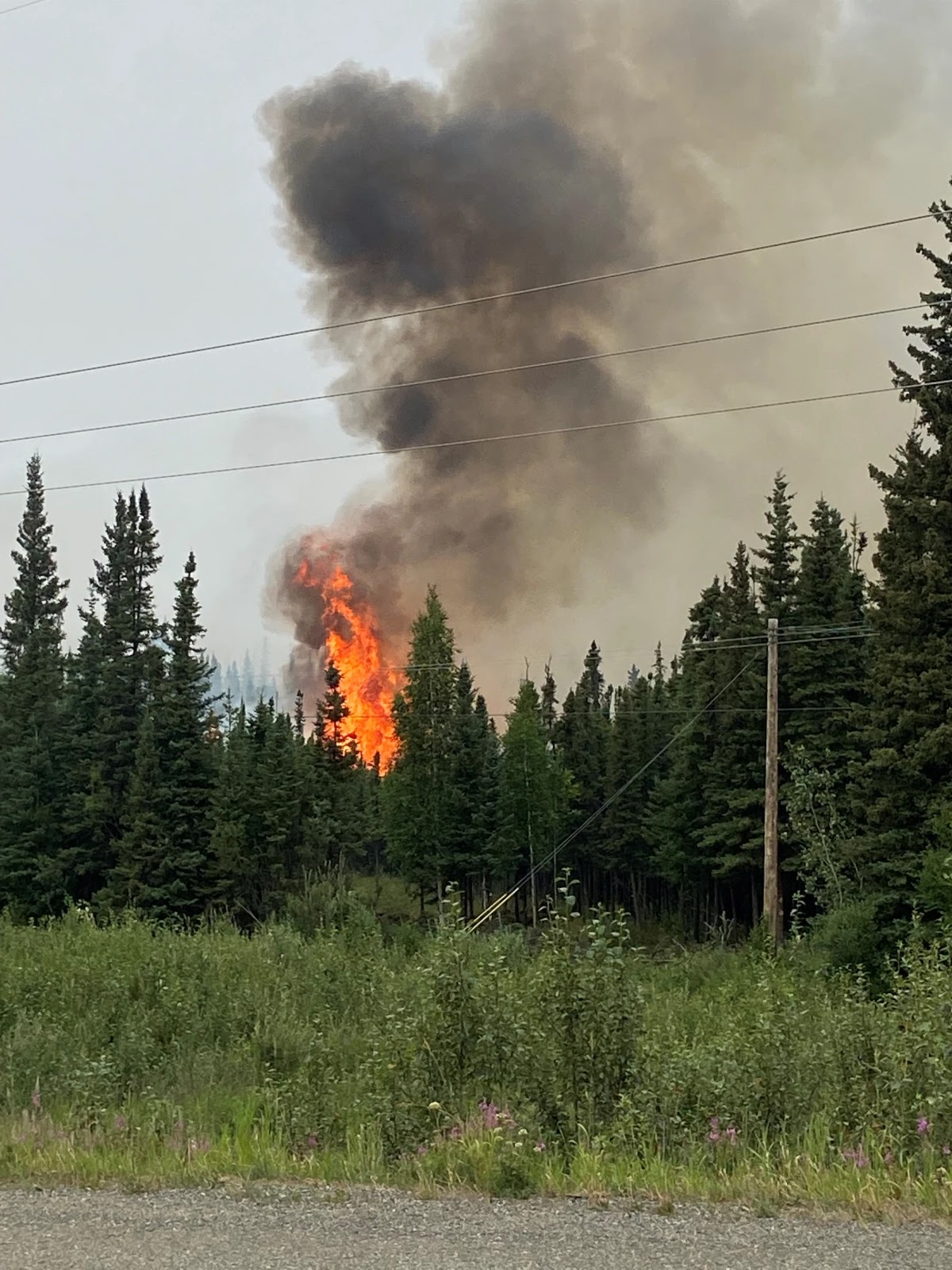 |
| A single tree torches while Clear Fire crews conduct strategic burning operations to protect power lines near the Parks Hwy on 7/9/22 |
 |
Photo by Bethany Urban, PIO with Northwest Team 10. |
July 9th, 2022
From Alaska Wildland Fire Information
(Clear, Alaska) – A RED FLAG WARNING has been issued for the fire area today. Conditions have set the stage for a critical fire weather environment, and residents who have chosen to stay in areas defined as “Go” are again ENCOURAGED TO EVACUATE. The area is unsafe and rescue attempts may place firefighters’ and citizens’ lives in danger.
Please slow down and remain alert while driving on the Parks Hwy and any other roads in the fire area. Conditions may be dusty and smoky with low visibility, and there are numerous fire apparatus and firefighters operating on these roads at all hours. Help us keep our firefighters and the public safe.
July 9th Map
July 7th, 2022
Over 500 people are working on this 60,000-acre fire. Hot weather and low humidity are making it worse. The fire grew 8,500 acres in a single day -- Wednesday. Fire crews have had to evacuate for safety. Residents of Clear were told to leave from Mile 273 to 281 on the Parks Highway. There are at least 155 people living in 140 structures in the endangered area, fire officials say.
 |
| Anderson fire helicopter. (Photo, DNR) |
July 7th Map
July 6th, 2022
Clear/Anderson Fire Breaches Dozer Lines
From Alaska Woodland Fire Information
Firefighters working on protecting structures in the Kobe Ag had to evacuate due to extreme fire behavior and life-threatening conditions.
Firefighters worked on community protection lines around Anderson Tuesday morning. The area is well prepared in the case of any fire movement toward the city of Anderson.
 |
Fire burns in the Kobe Ag subdivision near Anderson on the afternoon of 7/6/2022.
Photo credit: Eric Kiehn, Task Force Leader with Northwest Team 10 |